Op Khan National Park

Wednesday, September 2, 2009
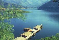
The Park boasts a variety of nationally important plants and wild animals, and its tranquility provides an ideal escape to enjoy untouched wilderness and natural beauty. It covers the areas of Samoeng, Hang Dong, Mae Wang, and San Pha Tong, with an approximate area of 484 km2 (302,500 rai). The geographical features of the park consist of high igneous and limestone mountains. Yod Khun Thian is the highest peak, rising to an altitude of 1,550 m. In the area, there are virgin arid, evergreen pine, and mixed forests. Op Khan is the source of many rivers and gullies flowing into the Mae Wang, Win and Khan Rivers.

In addition, the pretty and fragant orchid 'Ward Dendrobium' (Dendrobium wardianum Warner) is found only in this area of Thailand. This beautiful orchid blooms in January each year. Its Thai name 'Ueang Manee Tri Rong' means 'three-coloured jewel'. Its cute little petals are mostly white, with purples edging at their tips. The middles are yellow with brown at the center, giving it a unique and beautiful look.

The Park offers many attractions, including rivers, waterfalls, and hillside plains with traditional villages. Wild animals found in the National Park include gorals, Muliacus Muntjak, bears, fishing cats, mouse deer, masked palm civets, wild rabbits, wild boars, monkeys, slow loris, mongooses, porcupines, squirrels, tree shrews, rats, etc.

Op Khan Gorge
Op Khan Gorge is a strange and beautiful natural sightseeeing spot, which is just 450 m from park headquarters, accessible by foot. It originated from the erosion of cliffs on both sides of Mae Khan River. The River flows though 30 metre-high cliffs facing each other.

Activities: camping, hiking nature trails, cave / geological touring.

Huai Ya Si
Huai Ya Si is about 1 km from headquarters. It is a curved section of the Mae Khan River, where the river changes direction. The curve is almost 90 degrees, hence it slows down the river's flow considerably. Both banks of the gully are covered with Ya Si (Leersia hexandra SW), a lush green plant with beautiful blossoms. Huai Ya Sai is a small shallow gully suitable for swimming.

The sightseeing spot, built by the Park, provides breathtaking scenery, a tranquil atmosphere and the soothing sound of the winding Mae Khan River flowing past its rocky banks.

Pha Tub
Pha Toob, a small cliff standing beside a hill, is about 500 metres away from Huay Ya Si. From the base of Pha Toob, there is smooth detritus extending to the Mae Khan River. The everflowing current shapes the cliffs into interesting forms.

Huai Pong
Huai Pong stream is about 2 km from the headquarters, and is suitable for swimming. Visitors can also enjoy wild flowers along the trails.
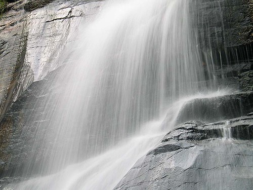
Mae Tian Waterfall
Mae Tian Waterfall is a single-level waterfall, originating from Mae Tian River. This waterfall is tapped for electricity by a power plant.

Tham Takkatan (Grasshopper Cave)
This large cave of 7,000 m in length contains stalactites, stalagmites. There are also ancient sculpted pictures adorn the cave walls.

Besides these attractions, Op Khan National Park contains Tham Doi Ton, Mae To Hot Springs, as well as other waterfalls for visitors to explore, such as Khun Puai Waterfall, Morakot Waterfall, Mae Mud Waterfall, Khun Win Waterfall, and Mae Wang Waterfall. In addition, the park also provides nature trails for hiking and leisurely walks.

Getting There:
From Chiang Mai, drive along Highway No.121 to Hang Dong for about 15 km, a scenic route hugging an irrigation canal. Then turn right on the Namprae - Op Khan Ro Pho Cho Road for about 10 km. Note that the road is steep and curvy! Visitors will arrive at park headquarters.

Pha Daeng National Park

Sunday, August 23, 2009
Previously, the park was named Chiang Dao National Park. Located in the north of Thailand, near Chiang Mai Town, it covers the area of Amphoe Chiang Dao, Amphoe Wiang Haeng and Amphoe Chai Prakan. The park’s 1,155 square kilometres encompasses high mountains and deep valleys of verdant forest. It is the limestone mountains in this area that feed the sparkling streams which eventually give rise to the mighty Mae Ping River.

The park’s highest peak is Doi Puk Phak Ka, which soars 1,794 metres above sea level and offers awesome panoramic views of the area, weather permitting, of course, as well as a cool year-round climate. Even in foggy times, however, the view can be quite striking.

Attractions in the park include:

Si Sangwan Waterfall – This captivating limestone cascade is just 150 m away from the park office. The waterfall is about 20 metres high. Set amidst lush green forest, the relaxing surrounding area provides idyllic beauty.

Huai Hok Waterfall – Perfect for adventurer-lovers, an 8-hour trek from the park office is required to reach this gem set amidst deep forest. It is accessible only on foot. The single-level waterfall is about 20 metres high and splashes down spectacularly into a large basin of crystal-clear water surrounded by lush greenery.

The Origin of the Ping River – The Mae Ping is one of the four major rivers of Northern Thailand. It originates from a small spring flowing endlessly from the mountain rocks, which is accessible only by foot, and the trek takes about 2 hours from the park office. Local villagers revere this gully as a sacred place. Therefore, each year at the beginning of the rice harvest, local villagers hold special rites here to pay homage to the spirit of the river, thanking her for her benevolence and life-giving beauty, and also apologizing for any possible insults. The rites are believed to usher in an auspicious harvest season. The villagers are kind and wholeheartedly respectful towards Mother Nature, and feel a great gratitude towards Nature in all her manifestations. These annual rites act to purify the people, and to ensure a warm, serene and respectful mindset in the participants themselves.

Pong Ang Hot Spring – The temperature of this natural hot spring is 70 – 80 degrees Celsius. It is located only 3 kilometres south of the park office. Pong Ang Hot Spring is a small natural hot water pool with water flowing all year round and is also a great place for bird watching. Many species of birds flock there, providing an ever-changing explosion of foliage.

Doi Pha Tang – This high rocky mountain has a gigantic round stone standing on it. It is located near km 93 on Highway 107 (Chiang Mai – Fang). From Dec – Jan, blooming Sakura flowers provide picturesque scenery. This area is home to the Chinese Haw, the Hmong and Yao minority groups. From the mountaintop, visitors can enjoy panoramic views of Thai and Lao rural areas. The mountain is most popular during winter when the cherry blossoms are in full bloom and a sea of mist covers the whole area.

Pang Tong Waterfall – The beautiful Pang Tong Waterfall is hidden among the lush green forest of the National Park. Originating from the Khun Mae Ngai River, the Waterfall is known for an interesting feature: the water flows through underground channels for 60 m before exiting through holes in the cliff face to become a dazzling waterfall with 3 levels and 2 sections.

Apart from its many waterfalls (nam tok) and gurgling streams, Pha Daeng National Park also offers highlights such as caves (tham) which are jeweled with exotic stalactites and stalagmites, such as Tham Pha Chan, Tham Doi Klang Mueang, and Tham Huai Cha Khan. There are also several more deliciously beautiful waterfalls, scented with the delicate aura of fine drops of mist, where visitors will enjoy scenic beauty mingled with the soothing sounds of the jungle canopy mixed with splashing water, such as Namtok Thung Kaeo and Op Ping.

The park boasts a gorgeous 2.5 kilometres nature trail that winds through a mix of deciduous forest and gently undulating slopes. The trail should take the average hiker between 2-3 hours to cover, and information is available at the Visitor’s Centre which is open daily from 8.30 am to 4.30 pm. The national park is adorned with a wide variety of flora and is home to fauna of many types.

Getting there – Take highway 107 (Chiang Mai – Fang) to km 79, then turn left and drive along highway 1178 for about 24 kilometres to Ban Na Wai. Turn left and continue for another 150 metres to the office of Pha Daeng National Park.

Doi Luang Chiang Dao

Wednesday, August 19, 2009
Doi Luang Chiang Dao is a limestone mountain in the Chiang Dao Wildlife Reserve area, Amphoe Chiang Dao. This cone-shaped mountain is 2,195 metres from sea level, which makes it the third highest mountain in Thailand after Doi Inthanon and Doi Pha Hom Pok. Narrow plains on top of the mountain overlook spectacular views that include a sea of fog on the Amphoe Chiang Dao side, Doi Sam Phi Nong, the Chiang Dao mountain range, and the far end of Doi Inthanon. The peak is cool and windy. It is full of rare highland flowers, birds, and butterflies. Visiting Doi Chiang Dao needs an approval letter from the Director of Wildlife Reserve Division, Royal Forest Department. Travel must be arranged at least 2 weeks in advance.

Descending the mountain is possible on the trail near Ban Tham, which is located near Chiang Dao cave. The trail is rather steep; nevertheless, it could shorten the walking distance upon descending. It is quite difficult to climb up.

Doi Tao Lake

Monday, August 17, 2009
The lake is located approximately 133 kilometers from Chiang Mai town along the Chiang Mai-Hot-Doi Tao route. This large reservoir is actually situated above the Bhumibol Dam in Tak province. The lake offers many recreational opportunities during the rainy and cool seasons, including rafting and cruise services to Bhumibol Dam. Accommodations are also available.

Ang Khang Royal Project

Friday, August 14, 2009
Located in the valley of Doi Ang Khang, the station is designated for conducting experiments on possible temperate plants to be grown in Thailand. The experiment is aimed at promoting the cultivation of cash crops to replace hill tribes opium plantations. Inside the station, there are beautiful landscaped flower gardens, a restaurant and plantations. Advanced contact is recommended for a group visit with lecturers available upon request. Facilities include guesthouses (inside the station), food and beverage, parking space, toilets, etc.

In addition, there are many guesthouses and a hotel located around the station. The entrance fee is 50 bahts per vehicle (including driver) and admission fee of 30 bahts per person. The morning market in front of the station, which is the hill tribes market, is stunning and charming.

Fang Hot Springs

Wednesday, August 12, 2009
These hot springs are situated at Ban Pin, which is located approximately 8 kilometers northwest of Fang city. The hot springs originate from simmering granite with temperatures from 90 to 100 degrees Celsius. Most notable is the largest spring which constantly jets out strong sulphur scented steam.

San Kamphaeng

Saturday, August 8, 2009
The village is located 13 kilometers the east of Chiang Mai town in a district that is famous for silk and a cotton weaving. The silk and cotton souvenirs produced in this village are high quality. Factories and souvenir shops selling woodcarving, silverware, earth ware, lacquer ware and cotton fabrics are located along the way from Chiang Mai to San Kamphaeng.

Located in San Kamphaeng is Bo Sang a village that produces handmade umbrellas. In addition to umbrellas, visitors will also be able to find various woodcarving and Thai silk products here.

Mountain Orchid

Tuesday, August 4, 2009
This plantation has been established for over 20 years and is famous for breeding a variety of species of orchids using appropriate technology. In addition to learning about orchid breeding, it is also possible to learn about various butterfly species. Facilities for tourists include toilets, parking area and beverage and souvenir shops. A lecturer is provided upon request. Advance contact is recommended for group visits.

Huai Hong Khrai Royal Development Study Centre

Thursday, July 30, 2009
Located in the forested area of Khun Mae Kuang, Doi Saket District, Chiang Mai Province, the Study Centre covers an area of over 3,000 acres. It was established on His Majesty King Bhumibol Adulyadej’s initiation in order to conduct studies and research on various development patterns such as forest development. The Royal initiative includes three classes of tree cultivation: those cultivated for fruit, those for firewood, and those cultivated for sale and purely economic benefits. This cultivation yields benefits according the value produced in each case, as well as a more diffuse benefit in terms of increased moisture retention in the soil and a general increase in the health of the land itself.

At the entrance to the Study Centre, the area begins with a forestry study project which has served to improve the environment in the Centre area, eliminate forest fires, and produce a moist climate bursting with fertile water sources. Subsequently, visitors will come upon facilities for ongoing studies of industrial agriculture and fishery studies at check dams, as well as farms for livestock and dairy cattle.

The Study Centre’s main aim is to function as a complete one-stop service centre replete with practical wisdom aptly demonstrated for farmers to learn and apply the model into practice. It also provides services, such as supporting animal husbandry activities and providing seeds, and giving advice and guidance on techniques which farmers can adopt in their daily lives. The Study Centre promotes the coexistence of man and land involving the distribution of the water supply to agricultural areas and the establishment of forest and fishery stations.

In the words of HM King Bhumibol, “Let this Study Centre function as living museum of Mother Nature.”

The Study Centre is open every day from 08:30-16:30, but visitors are advised to call ahead in order to obtain bungalow reservations and camping permission. Visitors must supply their own camping gear.

Tham Tap Tao Temple

Thursday, July 23, 2009
This temple is situated in Chai Prakan Sub-district along the Chiang Mai-Fang route between Km.120 and Km.121. Temple attractions include a scripture hall located in the middle of a pond and Tap Tao cave which houses several unique Buddha images.

Ban Rai Phai Ngam

Thursday, July 16, 2009
Located between Km.69 to 70 along Chiang Mai-Hot route, the place is famous for its high quality traditionally woven cotton. To get to the village from the main route, turn left and proceed for 1 kilometer until you seethe village sign.

Inthakhin Archaeological Site and Pottery Museum

Wednesday, July 15, 2009
The museum is situated at Ban San Pa Tong, Tambon Inthakhin, Amphoe Mae Taeng, Chiang Mai. It is an archaeological dig site which uncovered ancient Inthakhin kilns of the Mueang Kaen area of Thailand. Because of this, it is very important to Thai history and archaeology, helping to firmly establish the fact the Village of Phan Aek Phan Fuea Mueang Kaen actually existed in the ancient Kingdom of Lanna. Stone inscriptions have been found, dating back to the era of King Mengrai era (1258 – 1311 AD). It is also very important to the archaeology because kilns in good condition as well as beautiful examples of traditional pottery have been found here. Nowhere else in the Upper North have kilns or earthenware been found in such good condition as the ones unearthed here.

From the evidence found, archaeologists determine that these kilns were in use from approximately 1407-1457 AD, and it is assumed that the Ban San Pa Tong area was once a major producer of earthenware for the entire Lanna Kingdom. By the 14th century the art of glazed pottery making was widespread throughout Chiang Mai and the rest of the Lanna Kingdom.

Most of the earthenware found here are of the celadon type – with a light green or greenish-brown glaze – molded from extremely good quality white earth which can be compared with the Sangkhalok wares of Si Satchanalai, and with also specimens produced in Tao Phan Kiln in Chiang Rai Province. The products were uniquely strong and beautiful. Significantly, pre-fired ceramics molded from white earth have also been discovered, a find unduplicated in kiln sites anywhere else in Thailand.

This celadon glazed earthenware made Lanna famous in early times, although originally it traces its origins to China. The green glaze in especially treasured as it mimics jade, which is considered the most auspicious of Chinese colors and materials. Throughout this entire period, native Thai sensitivity, craftsmanship and artistic warmth imbued the pottery with unique flavour and vitality.

A nearby attraction is Mae Ngat Sombun Chon Dam, where visitors can relax at the water’s edge and dine surrounded by the natural environment.

Doi Mon Chong Mountain

Situated within the Omkoi Wildlife Sanctuary, which covers areas of Amphoe Omkoi in Chiang Mai Province and Amphoe Sam Ngao in Tak Province, Doi Mon Chong is a beautiful mountain retreat in Northern Thailand. Attractions include the nearly-extinct and therefore protected mountain goat, as well as breathtaking mountainscape vistas. Thailand’s largest Azelia (Rhododendron sp.), which blooms from December to January, adorns the mountains with its red-, pink-, and white-petaled blooms. The landscape includes peaceful, sweeping hills and wide open grassy plains. The forests and plains are home to many rare birds and other creatures.

Hiking trip up Doi Mon Chong can be done within a day, but it would be a very exhausting trip which should not be begun any later than 6:30 am. Hikers are advised to spend at least 2 days and 1 night for a more pleasurable visit. In addition, advance permission is required from Omkoi Wildlife Sanctuary at Musoe Unit, where the office of Wildlife Sanctuary is located.

Getting There:
By Car From Chiang Mai, take Highway 108, then take a left turn from Amphoe Hot to Highway 1099 and continue to Amphoe Omkoi. Musoe Unit is on the left after 40 kilometres. From the Unit to the trailhead is a 16 kilometres drive on an unpaved, windy cliff road. Needless to say, it requires a 4WD vehicle as well as a skillful driver.

By Bus Busses leave from Chang Phueak Gate in Chiang Mai, taking passengers to Omkoi Town. Service starts 8 am. Mr. Det Soemmatiwong ferries passengers to and from the trailhead.
Visitors can buy supplies in Omkoi Town. A porter can be hired for 150 baht per day.

Doi Wiang Pha National Park

Tuesday, July 14, 2009
This park covers the area of Chai Prakan District and Fang District, in Chiang Mai Province. This area provides the watershed for many major rivers, particularly the Fang River as well as branches of the Lao river such as the Mae Fang Luang, the Mae Fang Noi, and the Yang Min River.

The geographical features of the National Park consist of high mountains, extending northwards and forming a boundary between Chiang Mai and Chiang Rai provinces. Doi Wiang Pha is the highest mountain of the National Park, with a maximum elevation of 1,834 meters above sea level. The forests in the area are evergreen and mixed forests. The weather here can be divided into 3 seasons. The rainy season lasts from May to October, and it usually rains most heavily in September. Winter is from November to February, when the weather is fresh and inviting – ideal for travelling. Winter mornings tend to be foggy. March to April is the summertime, when the weather is rather hot.

There are a variety of virgin forests in the National Park, including evergreen, pine, timber forests, and mixed forests, depending on the altitude of the areas. Major tree types are teak, rubber, Leguminosae (Pradu), Michelia Alba, Pinus Merkusii Jungh (two-leaf pines), different kinds of Lithocarpus Cantleyanus (Ko), and the forests also include many types of moss, ferns, orchids, etc.

Due to its abundance of forests, varieties of plants, and different altitudes, the National Park has become the source of food and dwelling places for many different kinds of wild animals including Muntiacus Muntjak, wild boars, gorals, porcupines, wild rabbits, monkeys, masked palm civets, squirrels, tree shrews, and different kinds of birds such as White-rumped Shama, turtle doves, hawks, while fowls, etc.

The Park boasts great lookout points where visitors may experience the natural charms of the mountain range at dawn, in twilight or in the full blaze of day. Many high-altitude plants are found on the mountain top such as Azelia (Rhododendron sp.) and many other types of grasses and flowers.

The Park contains many waterfalls, but most of them are hard to access because the Park landscape is still being developed. The waterfall which is most convenient to access is Huai Sai Khao Waterfall. It is located in the area of the Park headquarters. Huai Sai Khao is a triple-level waterfall with basin suitable for swimming. The flow is most prodigious from May – November. The uppermost level is sandy since the rock above the waterfall is sandstone. The environment around the Waterfall is so moist that all the rocks are covered with cute green moss.

Other waterfalls in the area are Mae Fang Luang Waterfall, Doi Wiang Pha Waterfall and Huai Han Waterfall. All of these are small falls.

The Park has two bungalows. Contact Doi Wiang Pha National Park. P.O. Box 14, Amphoe Chai Prakan, Chiang Mai, Thailand 50320.

Getting There:
By car
From Chiang Mai Town, take Highway No.107 for about 125 kilometres. 2 kilometres before reaching Chai Prakan District, the park entrance is opposite Si Dong Yen School. Continue for another 12 kilometres to Park headquarters.

Bua Tong Waterfall and Nam Phu Chet Si

Monday, July 13, 2009
Nam Phu means fountain – or in this case geyser – and Chet Si means 7 colours. This bejeweled waterfall is located in the area of KM 42 of the Chiang Mai – Phrao Road in Ho Phra Sub-district, Mae Taeng District. It is a mineral geyser containing calcium-carbonate, gushing from the ground and then overflowing streams and small waterfalls. Its streambed is solid white, glittering crusted with calcium carbonate. Sunshine reflected from the clear flowing and falling water, as well as the white stream bed, makes for quite impressive natural scenery.

Pa Kia Doi Chiang Dao

Sunday, July 12, 2009
This research station is under the Faculty of Agriculture, Chiang Mai University. It is situated in a beautiful area from which visitors can clearly view magnificent Doi Luang Chiang Dao Mountain. The area is full of bird life, making it a great spot for bird watching. In the cool season the mountains are blanketed by a sea of fog in the mornings, and evening skies are dark and clear and full of stars. The lights from Chiang Dao Town shimmer far below.


Getting there:
Take Highway 107 from Chiang Mai via Mae Rim and Mae Malai (visitors can buy supplies here at Mae Malai market), and Mae Taeng. Continue till you reach Ban Mae Na, where there is a separate left turn with a sign for ‘Mae Taman Watershed Management Unit’. After about 21 kilometres there is an intersection. Turn right. This road is steep and unpaved and leads to Pang Hong Village and Pang Hang Village. The road continues and becomes steeper. Go straight past the turnoff for the Pa Den Ya Khat Ranger Station. Turn right towards Ban San Pa Kia School. From there, continue to the Mae Taman Watershed Management Unit. The Research Station is about 500 m up the road, which is very steep.

Getting back:
From the Station, visitors can get back on Highway 107 via Kaeng Phan Tao Village. Approximately 12 kilometres from the Station, visitors will find an intersection. Turning either right or left will bring you to the main road. Going right, the road passes Pak Iak Village, tea plantations and a hilltribe community. The road is paved but is still rather steep. It leads to Kaeng Phan Tao Village and Highway 107.

Accommodations and facilities:
Dorms for students of the Agriculture Faculty, Chiang Mai University are available, as well as bathrooms and kitchens equipped with utensils, but visitors have to bring their own food. The fee is 50 baht per person per night.

Mae Ta-khrai National Park

Friday, July 10, 2009
The Park covers 350 square kilometres of Chiang Mai Province and Lamphun Province, with a landscape of rugged mountains reaching up to 2,030 m. There are various pine, evergreen and mixed forests on the mountains and valley slopes, which are the source of streams eventually giving rise to the Ping River. The forest area is the habitat of different birds, deer, gibbons, wild boars, etc. The weather is generally cool and breezy, although the summer can get quite hot.

Attractions:
Mae Ta-khrai Check Dam
Park headquarters is situated here among mixed forests and bamboo groves. A 3-km nature trail rings the Check Dam.

Tat Moei Waterfall
Soaring 15 metres in height, Tat Moei is very spectacular, especially in the rainy season when its flow is swollen with runoff. The waterfall is about 16 kilometres away from Park headquarters and reaching it requires a 3 km hike through forests.


Mae Ta-khrai Waterfall
This is a single-level waterfall, 6 kilometres away from Park headquarters. Along the way, there are various kinds of plants, mushrooms and wild flowers.

View Points
2 view points can be visited on the Mae Ta-khrai - Huai Kaeo road. The first one is at KM 6, offering panoramic mountain vistas of the range which forms the border between Chiang Mai Province and Lam Pang Province. The second one is another 600 m away, and is likewise quite impressive. Notably, it possesses a supreme view of Chiang Mai Town and Doi Suthep which is impossible to obtain elsewhere. At night, shimmering lights from the town far below seem to create a sea of stars on Earth, nestled in the arms of the valley.


Doi Langka (Phu Langka Luang)
With an altitude of 2,030 m above sea level, this is the fifth-highest mountain in the country. The climate is fresh and cool all year round. Wide open grassy plains sweep across the mountaintop. The area is especially beautiful between February and March, when Azelia (Rhododendron sp.) is in full bloom. Phu Langka Luang lies 50 kilometres north of Park headquarters. Getting there:
By car: Drive to Kamphaeng Hin Village, then hike the 12 kilometres up to the mountaintop.
By foot: Hike up to Doi Langka from Khun Chae National Park. The trip takes 2 days. Visitors can do both – hike one way and travel by car the other way.

Getting to Mae Ta-khrai National Park:
From Chiang Mai Town, take Highway 1006 to King Amphoe Mae-on. At the intersection in front of Pao Sam Kha School, turn right onto Highway 1229 and continue for 4 kilometres to Check Point 1. After another 10 kilometres take the right turn in the direction of Ban Huai Kaeo. Park headquarters and the Check Dam are about 800 m further on.


Mae Tho National Park

The park is located approximately 160 kilometers from Chiang Mai town. To get there, drive along the Hot-Mae Sariang Road to Mae Tho for 16 kilometers, at Km. 55, turn onto the unpaved roads which are steep and curved. Only vehicles in good condition are recommended. The Mae Tho National Park Office overlooks Karen highland paddy fields that resemble a flowing stream. Camping and trekking is possible by contacting the national park office.

Op Luang National Park

Thursday, July 9, 2009
Op Luang National Park is an amazing natural attraction comprising both splendid natural charms as well as mysterious scenery. A zigzagging river flows in front of a picturesque gorge. The area is a high, steep cliff with a narrow passage, creating strong currents and powerful echoes. An area in the north of this stream is teeming with various kinds of plants that provide a pleasant ambience all year round. Magnificent views of Op Luang National Park can be seen from the bridge that links with the gorge. An interesting prehistoric archaeological site is also located in the park.

Mae Sa Waterfall

Wednesday, July 8, 2009
This famous 8-tiered waterfall which is located at Km. 7 along the Mae Rim-Samoeng route is situated in a natural setting among towering trees and has a lovely breeze flowing throughout the year. It is an ideal recreational spot for both residents and visitors.

Mok Fa Waterfall

This one-level waterfall is located on the Mae Malai-Pai road. To get there, take a left turn at Km. 20 onto a dirt road and proceed for 2 kilometers. The waterfall, which is surrounded with lush green trees, is full of water all year round.

Namtok Mae Pan

Monday, June 15, 2009
Namtok Mae Pan is the longest waterfall in Chiang Mai, which flows from a 100-metre cliff. Its charm can be enjoyed by standing some distance from the falls. From afar, the white water and the green forests around the falls make a beautiful picture. From Km. 38 of Highway No. 1009, drive along the Doi Inthanon-Mae Chaem road (Highway No. 1192) for 6 kilometres and a sign to the waterfall will be seen, then drive on an unpaved road for 9 kilometres. The lovely waterfall can be reached by a ten-minute walk from a parking lot. In the rainy season, the road to Namtok Mae Phan is in a poor condition; only a four-wheel vehicle could make the journey.

Namtok Huai Sai Lueang

Saturday, June 13, 2009
Is beyond Namtok Mae Pan, about 21 kilometres from Doi Inthanon-Mae Chaem Road. Turn left to an unpaved road where only a four-wheel vehicle could make a trip in the rainy season. The medium-size cascade has water all year round and flows from a cliff to each level.

Ang Ka Luang Nature

Trail was surveyed and designed by Mr. Michael MacMillan Walls, a Canadian volunteer biologist who devoted to his work and died from a heart attack on this mountain. This trail is 360 metres long, passing through wet and cold areas in a lush valley. Forest above 2,000 metres is covered with lichens and wild orchids. Indigenous plants that needs a high level of nutrition, organic deposits, and rare species of birds are seen along the trail.

There are more nature trails on Doi Inthanon, each providing different views of the diversity of plants, reforestation, the importance of tributaries, the origin of caves, hilltribe agriculture, and birdwatching. Walking trails range from 1 to 8 kilometres. Each trip needs approval from the Chief of the National Park and a trekking leader is needed. The service is obtained at the Park Office at Km. 31.

Doi Ang Khang National Park, Chiang Mai

Friday, June 12, 2009
Famous for its cool climate all year round, visitors can explore the Royal Angkhang Station Project and visit hill tribe villages to learn more about their daily life. To get there, take Highway No. 107 (Chiang Mai-Fang), turn left at an intersection around Km. 137 (Mae Kha Market) and proceed for another 25 kilometers to Doi Ang Khang. As the route is filled with steep s-curves, an experienced driver and vehicles in good condition is required. The local truck (song taew) from Mae Kha Market offers chartered service to the mountain.

Tham Bori Chinda

Tham Bori Chinda is a large cave located near Namtok Mae Klang at Km. 8.5 of Highway No. 1009. The road sign to Tham Bori Chinda will be seen at the junction on the right. The deep cave has stalactite and stalagmite formations, Buddha images and a rocky stream. The surface of the water glitters like diamonds flake when light reflects the stream. Sunlight in the cave allows visitors to see the entire cave.

The Tourist Centre at Km. 9 has exhibits on nature and animals that inhabit the area.

Namtok Mae Klang

Monday, May 25, 2009
is a 100-metre one-level waterfall located 8 kilometres from Highway No. 1009 junction and turn left onto an asphalt road for 500 metres.

Namtok Mae Ya

Thursday, May 21, 2009
Is one of the most beautiful cascades in Chiang Mai. Water flows from a 280-metre steep cliff onto different rock formations in a lower basin like drapes. The well-managed waterfall is teeming with verdant forests and is best for recreation. It is located 1 kilometre from Highway No. 1009 junction, turn left for 14 kilometres and then take a 200-metre walk.

Doi Inthanon

This national park which covers an area of 1,005 square kilometers is located on Doi Inthanon, Thailand’s highest mountain which is 2,565 meters above sea level. Located between Mae Chaem and Chom Thong, the park is comprised of the largest tract of upper mountain forest which ranges across Nepal, Bhutan, Myanmar, and ends in Northern Thailand. The mountain ranges gave birth to the main tributaries of the Ping river and formed the beautiful waterfalls, namely Siriphum, Wachirathan, Mae Pan, Mae Klang and Mae Ya. The moist and dense evergreen forest is abundant with lichens and wild orchids. The park is also a paradise for bird lovers.

Visiting Doi Inthanon is possible throughout the year however, the best period for viewing the waterfalls is May through November while the best period for viewing wild flowers is December through February and for ornithologists is November through March.

Getting there: Travel 58 kilometres west of Chiang Mai via Highway No. 108 to Chom Thong, then turn right into Highway No. 1009 and continue a further distance of 48 kilometres along Highway No. 1009 to the summit. A good asphalt road takes visitors up but is rather steep, thus the vehicle must be in a good condition. Visitors could pay for the entrance fee at Km. 8.

Doi Inthanon can be reached by a local truck (Song Thaeo) from Phra That Chom Thong or Mae Klang Waterfall. The Song Thaeo runs to Doi Inthanon National Park Office (Km. 31) and neighbouring villages. A chartered Song Thaeo costing around 800 baht can make stops at other attractions around the area.

Admission : adult 400 baht, child 200 baht

Travel to Chiang Mai, Thailand

Welcome to my blog,Travel to Chiang Mai. Here you will know about Chiang Mai In Thailand and how to Travel to Chiang Mai, tips for Travel to Chiang Mai and more about Travel to Chiang Mai.